Platform
A smarter way to understand infrastructure
Phyll transforms imagery into intelligence. Continuous. Persistent. Actionable.
How it works
From raw footage to persistent infrastructure memory
Every frame becomes an observation. Every observation resolves to an entity. Every entity accumulates state. Every state change becomes a delta. The result: an auditable system of record for the physical world.
Capture
Ingest heterogeneous imagery from any existing source — dashcams, body cameras, drones, CCTV networks, phones, or fleet vehicles. No new hardware, no disruption to existing operations.
Understand
AI detection and condition models process footage by source type and angle. Different model paths for ground-level vs. aerial vs. oblique imagery. Proprietary datasets for infrastructure-specific asset classes and defect conditions not covered by generic models.
Remember
Each detected asset is resolved against existing records using geolocation, appearance, geometry, OCR/symbols, and temporal priors. The same real-world asset is recognised across different cameras, angles, seasons, and time — and assigned a durable persistent ID. State-to-state deltas are tied to the asset itself, not just frame comparisons.
Act
Intelligence flows directly into the tools teams already use — GIS platforms, asset management systems, risk dashboards, underwriting workflows, maintenance queues, and operations consoles.
Coverage
The cameras are already there.
Camera partners give Phyll on-demand reach across the US and EU — no deployment, no new hardware.
Request coverage →Economics
How the math works
Infrastructure intelligence at a cost that makes continuous monitoring feasible at scale.
Price per mile — relative comparison
50–100× lower cost per mile than traditional inspection methods
Key outputs
Decision-ready intelligence
Risk Alerts
Real-time notification of new hazards, damage, or condition changes on monitored assets.
Asset Condition Monitoring
Continuous health scores and condition trends for every tracked asset.
Maintenance Prioritisation
Ranked queues of assets requiring attention, ordered by urgency and risk.
Infrastructure Intelligence Dashboards
Unified views of asset health, change history, and exposure across portfolios.
Change Detection Reports
Before/after comparisons for any asset, corridor, or site at any point in time.
Historical Infrastructure Records
A permanent, queryable record of every asset state and event over time.
Why it's hard to replicate
Detection is the commodity. Memory is the moat.
Any team can run a detector. No team can instantly copy historical footage, repeat-pass coverage, customer workflows, asset-level histories, and years of temporal signal.
Fleets and operators capture the world but overwrite it every 30 days. Once Phyll stores it, that historical moment is proprietary inventory that can't be retroactively sourced.
Raw footage becomes structured observations with source, time, location, confidence, model version, and provenance — not just detections.
The same real-world asset is recognised across sensor type, angle, time, condition, and capture quality using a multi-signal match graph.
The valuable object is the asset history: state-to-state changes tied to asset_id with evidence and auditability — not isolated frame comparisons.
More footage → better models → better intelligence → more customers → more footage. Every observation makes the system harder to replicate.
Temporal histories become training data for deterioration forecasting, risk progression, outage likelihood, and maintenance prioritisation.
Data & Security
We are not building Big Brother.
Phyll delivers infrastructure asset intelligence — not surveillance. We process footage for physical asset conditions and defects. People, vehicles, and non-infrastructure entities are not our product.
Personal data is removed as early in the pipeline as possible, and never enters the asset record. We retain imagery to build asset history over time — that history is the product. Retention of customer-supplied media is set by each agreement. Customer data never leaves permissioned environments.
Phyll is a data and analytics provider, not an insurance intermediary. Our outputs are factual condition observations and are not underwriting, actuarial, or valuation advice.
Traditional systems
Capture & retain everything
- Faces & identities
- License plates
- Pedestrians
- Vehicles & movement
- Everything in frame
PII retained in the record
Phyll
Infrastructure assets only
- Hydrants & utility poles
- Signs & signals
- Road & pavement condition
- Roofs & structures
- Guardrails & barriers
PII never enters the asset record
Data ownership guaranteed
Media you supply stays yours. Where Phyll captures on your behalf, you get a perpetual licence to the deliverables and can share them with your carriers, brokers, and insureds. Rights are set out in full in every agreement.
Personal data minimised
Partner-supplied imagery typically arrives already redacted. In situations where it does not, or is captured by the Phyll team, Phyll performs automated face and plate blurring at ingest. Personal data is never written to the asset record and is never used to identify or track anyone.
Permissioned access controls
Role-based access controls and permissioned data sharing across all customer environments.
Private deployment available
Phyll can operate within your infrastructure — on-premise or in your cloud tenancy — with no external data movement.
Infrastructure-only outputs
Deliverables are structured data about physical assets: conditions, locations, change deltas. Not footage. Not surveillance.
Compliance roadmap
SOC 2, ISO 27001, and sector-specific compliance (NIST, insurance data standards) on the product roadmap.
Source frame · dashcam pass
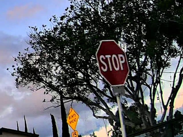
Structured output
{
  "asset_id": "3a5d5884",
  "class": "stop_sign",
  "condition": "Good",
  "location": { "lat": 32.8452,
                "lon": -117.0151 },
  "confidence": 0.94,
  "source": "dashcam",
  "captured": "2026-05-15",
  "observations": 3
}
Ready to run a pilot?
Upload footage from a corridor, site, or fleet. Receive map outputs, detections, and change reports within days.
Talk to us about a pilot